The History of the Cape San Blas Lighthouse
Cape San Blas is a 750-acre section of land that juts out into the hurricane prone Gulf of Mexico from the crook of the narrow St. Joseph's peninsula, located near the town of Port St. Joe, Florida. A dangerous shoal extends out five to six miles from Cape San Blas creating a major navigational hazard to ships traveling along the coast during the 19th and 20th centuries.
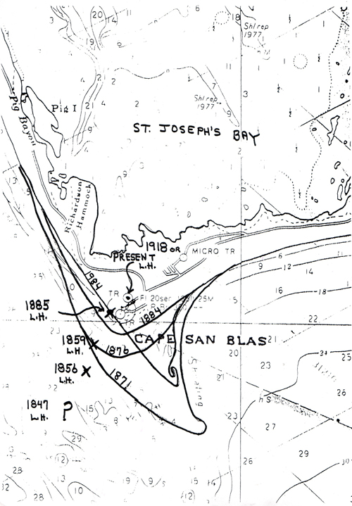
To warn seafarers of the hazard, in 1847 Congress appropriated $8,000 for a lighthouse. Two years later a conical brick tower was completed. The signal from the 85-foot high structure could be seen for 10 miles offshore (
view erosion map for approximate location).
During a storm in 1851, this first structure was destroyed.
In 1857 a brick lighthouse was again erected, just prior to the beginning of the War Between the States. The wooden parts of the tower and both keepers' houses were burned by Confederates. The lens, oil, and tools were hidden away in Apalachicola, preserved for future use. The lighthouse returned to operation on July 23, 1865. (
view erosion map for approximate location).
In 1869, the Lighthouse Board reported that the beach in front of the lighthouse was eroding swiftly and needed protection from the sea's encroachment. By 1875, the waters of the Gulf had moved to within 150 feet of the tower's base. By 1882, it stood in eight feet of water (
view erosion map).
In 1883, the Lighthouse Board approved the erection of a skeletal tower (
view photo). The "skeletal" lighthouse has eight cast iron legs that support the "watch room" and lantern at the top of the tower. The legs are bolted into a concrete foundation. This type construction allowed less resistance to wind-and-wave action and reduced the weight of the structure on the soft, sandy earth. Access to the lantern is up a central, cast-iron-plate cylinder with a spiral metal stairway.
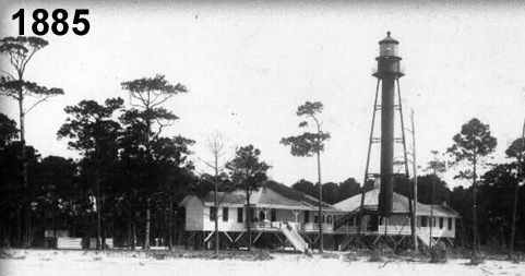
The skeletal tower was built in the north and sent by ship to the Cape; however, on the west coast of Florida, the ship sank losing its precious cargo. Because the water was relatively shallow, most of the tower was salvaged and shipped on to its destination. The third-order Fresnel lens was lit in June 1885.
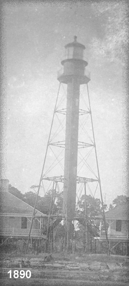
The new 98 foot skeletal tower was erected 1500 feet from the shore (
view photo), but by 1890, the erosion had left only 144 feet of land between the tower and the Gulf. Before it could be moved again, a powerful storm hit October 8 and 9, 1894, leaving the tower damaged and standing in water.
The decision was made to move the lighthouse to Black's Island but funds ran out before the move was completed. The Lighthouse Board decided to move the tower inland, but because the sand had begun to build up in the area, it was decided to take no action at the time.
Manufactured in 1905 by Rarbier Benard & Ture in France, the third-order bi-valve (or "clam shell") lens is made of over two hundred cast-glass prisms, each hand polished to optic quality and precise dimensions. The prisms are set into a bronze frame. At 101 feet above sea level, the electric beacon could be seen for 16 miles as it flashed white for one second every twenty seconds.
In 1916 a hurricane hit the area and plans were once again made to move the tower inland. In 1918 it was moved one quarter mile inland and the light was lit on January 22, 1919 (
view erosion map for approximate location). The brick oil storage building has survived and can be seen on the grounds at its new home.
Until 1952, the property was solely used as a site for the lighthouse. The Coast Guard, part of the Department of Transportation, assumed custody of approximately one-third of the peninsula. They also assumed responsibility for operation of the LORAN station and lighthouse. The lighthouse station was used as a manned LORAN Station until 1972 when it was automated.
The keeper's quarters were left unattended for several years, and began to deteriorate. In 1996 the lighthouse was deactivated, and two years later, the dwelling that was closest to the shore received considerable damage from Hurricane Earl.
In 1999, after the Air Force assumed responsibility for the keeper's dwellings, the two structures were moved to a site near the tower. The dwelling that was in the best condition was restored at that time for use by the US Air Force, while the second dwelling had to wait until 2005 when Sleeping Beauty was awakened by her Prince and once more became alive and a vibrant reminder of life at a Keepers' Quarters in the early 20th century.
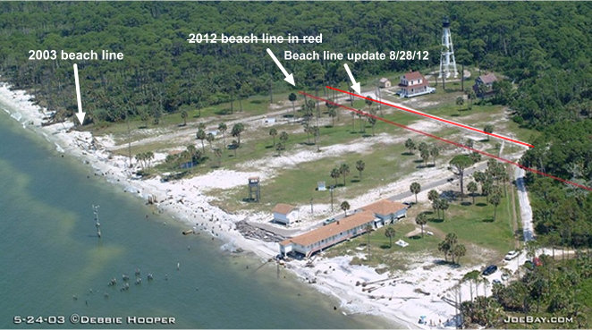
The United States Air Force closed the Cape San Blas Lighthouse District on October 12, 2012, due to the continued rapid erosion of the coast line. (
view 2003 aerial photo showing erosion)
On December 14, 2012, the United States Air Force had the two Keepers' Quarters and Oil Shed were moved inland approximately 135 feet to prevent imminent destruction of these structures. (
view 2012 aerial photo)
The City of Port St. Joe received Constructive Possession of the Cape San Blas Lighthouse District on February 22, 2013.
The United States of America, by and through the Secretary of the United States Department of the Interior and the Southeast Regional Director, National Park Service did release and quitclaim to the City of Port St. Joe on July 30, 2013, the Cape San Blas Lighthouse District. The United States Coast Guard retained ownership of the third order Fresnel Lens.
On July 15, 2014, the Cape San Blas Lighthouse, two Keepers Quarters', and Oil Shed were relocated to Core Park in Port St. Joe to preserve each structure in perpetuity (see
photos and
videos on this website).
The Cape San Blas Lighthouse at Port St. Joe was opened on September 12, 2014, to visitors.
On May 7, 2015, the Cape San Blas Lighthouse District was listed on the National Register of Historic Places.
The St. Joseph Historical Society Inc., gratefully acknowledges the many individuals and organizations that have made the preservation and restoration of the Cape San Blas Lighthouse and Keepers Quarters a reality. Without their support, preservation and restoration of this facility would not have been possible. The concerted efforts of the Gulf County Board of County Commissioners, Florida Department of State - Division of Historical Preservation, United States Air Force - Eglin Air Force Base, Randy Lewis - Manausa Lewis and Dodson Architects, Dimitri Gioglis - New Millennium Construction Company, Alfred I. duPont Foundation, Restocon Corporation, Architectural Metal and Design, Inc., and the Northwest Florida Improvement Foundation.
The relocation of the Cape San Blas Lighthouse Complex was made possible through the concerted efforts of the US Department of Interior, National Park Service, the City of Port St. Joe, St. Joseph Historical Society, Inc., State of Florida Division of Historical Resources, Florida Lighthouse Association, Duke Energy, various grants, and individual contributions. Without their collaboration, the relocation and preservation of the Cape San Blas Lighthouse Complex would not have been possible.